Using Ordnance Survey maps
If you live in Great Britain then you will know that the Ordnance Survey produces a great set of 1:25,000 and 1:50,000 topographic maps. What makes them particularly attractive is that the illustrate tracks that open for vehicle use. These are known as Green Lanes or Byways. The down side is that they are not 'open data' (i.e. free) and generally require a subscription of some sort. That said there some ways to view the maps freely on a PC or mobile device.
Greenlaning
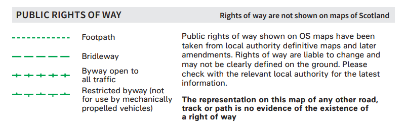
Green laning is adventure driving on what are usually un-surfaced lanes, tracks or trails that are open for motorised vehicles to use. Also known as byways, green lanes are often overgrown and twist through the countryside very much off the beaten track. Green lanes are officially classified at BOATs (Byways Open To All Traffic or UCRs (Unclassified Country Roads). For more information see Green Lane Association (GLASS) or the Trail Riders Fellowship
To identify the Green Lanes on a map look for the 'Byway open to all traffic' symbology.
Add Ordnance Survey maps to Nakarte web viewer
The Ordnance Survey maps are already hard baked into Narkate. Please see
Ordnance Survey maps from Bing
The Ordnance Survey maps that the Narkate web viewer uses are licenced by Microsoft. I can't actually determine when they were published but suspect that they are not current. Before relying on them (especially the Byways Open To All Traffic tracks) do check other sources.